
Early in the day, Kansans woke to scattered morning storms, primarily along and east of Interstate 135. These showers are expected to taper off by late morning, with no heavy or severe weather anticipated.
As the clouds clear, sunshine returns across much of the region, setting the stage for a warm afternoon. Expect highs in the upper 70s to lower 80s today as summer makes its comeback.
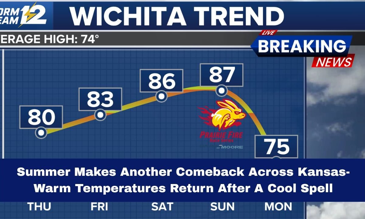
Full Summer Returns Tomorrow and Through the Weekend

By Friday, summer conditions fully assert themselves—with highs in the lower 80s. The heat intensifies heading into the weekend, where Saturday and Sunday will bring middle to upper 80s temperatures.
However, the warmth comes with gusty southerly winds, occasionally exceeding 40 mph, especially on Sunday, making it feel hotter and stirring up dust in dry regions.
Temperature & Weather Forecast Snapshot
| Day | High Temp Range | Conditions & Notes |
|---|---|---|
| Today | Upper 70s to Lower 80s | Cloud clearing, storms ending by late morning |
| Friday | Low 80s | Sunny and warm |
| Saturday | Mid to Upper 80s | Strong sunshine, persistent warmth |
| Sunday | Mid to Upper 80s | Windy with gusts over 40 mph |
| Sunday Night | Slight drop to 70s | Cold front approaches; showers east/central |
| Monday–Tuesday | Upper 70s | Cooler but still comfortable |
| Wednesday onward | Rebound into 80s | Summer returns again |
Cold Front Arrives Sunday Night
The next cold front is expected to sweep through Sunday night, bringing chances of showers or storms, primarily across central and eastern Kansas.

However, the front will offer only a modest cooldown — temperatures on Monday and Tuesday will dip into the 70s, a slight break from the 80s but still within comfortable summer range.
Summer Strikes Back Midweek
By Wednesday, summer returns with a vengeance. Temperatures rebound into the 80s and are expected to remain elevated through the rest of the week. The warm spell may extend late into next week, bringing renewed heat, sunshine, and potentially stronger afternoon wind gusts.
What This Means for Kansans
- Outdoor plans thrive: This is a great window for yard work, recreation, and weekend getaways before the next front moves in.
- Wind concerns: Gusts over 40 mph could pose issues for driving high-profile vehicles, dust on rural roads, and outdoor events on Sunday.
- Moisture chances: Showers Sunday night could bring beneficial moisture, especially where soils are dry.
- Temperature swings: The drop into the 70s early next week will feel like a break, but summer returns swiftly afterward.
After a brief cooldown and morning storms, summer is staging its return across Kansas. The next several days bring warm sun, rising temps, and gusty winds, with highs consistently in the 80s.

Though a cold front will creep through Sunday night, it offers only minor relief before heat returns midweek. For now, Kansas is back in full summer mode—time to soak up the sun responsibly and enjoy the warmth while it lasts.