
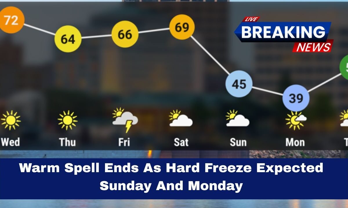
A mild stretch of weather across Kansas is ending as a sharp cold front moves in this weekend.
Expect the warm temperatures to vanish quickly and give way to a significant hard freeze in many areas of the state, including the Wichita region and the Kansas City metro area.
What To expect
- Sunday (daytime): Highs will struggle to reach the upper 30s to low 40s °F. The cold air arrives early and makes it feel much chillier than current conditions.
- Sunday night into Monday morning: Lows will drop to the low–mid 20s °F, possibly even the upper teens in some northern locales. Widespread hard freeze conditions are expected.
- Monday (daytime): Highs return to the low to mid 40s °F, but that still lies well below the previous warm spell, so expect lingering autumn chill.
- Winds: Northwest winds of 20-35 mph become gusty and will drive wind-chills into the teens and 20s °F in the mornings and evenings.
- Precipitation: A small chance of sprinkles or flurries late Saturday night or early Sunday morning. No significant snow or ice accumulation is expected.
- Warm-up: After Monday’s chill, temperatures are expected to gradually rise by Tuesday and mid-week, trending back toward the 60s °F.
Forecast
| Day & Date | Region | High (°F) | Low (°F) | Notes |
|---|---|---|---|---|
| Saturday | Statewide | ~60-65 | ~30-33 | Cold front arrives; winds increase |
| Sunday | Statewide | ~39-43 | ~22-26 | Very cold day; hard freeze likely at night |
| Monday | Statewide | ~42-46 | ~34-38 | Cold morning; slow recovery |
| Tuesday | Statewide | ~55-60+ | ~40-45 | Warming trend begins |
Why this matters in Kansas

The flip from mild to cold is dramatic. The warm spell had many areas in the 60s °F earlier this week, but the incoming Arctic air mass behind the cold front will cause temperatures to fall sharply.
The combination of clear skies overnight, light winds after the front passes, and recent warm ground temperatures means the risk of a damaging freeze is heightened for plants, outdoor plumbing, and exposed systems.
What you should do now
- Shield plants & landscaping: Move potted plants indoors or into a garage. Cover tender outdoor plants with breathable fabric or mulch their roots.
- Winterize water systems: Unhook garden hoses, drain backflow preventers and sprinkler systems, cover outdoor spigots and any exposed pipes.
- Pets & livestock: Provide shelter from wind, fresh bedding, and ensure water sources won’t freeze.
- Vehicle & home prep: Check antifreeze, battery, tire pressure, and make sure your home heating system is ready. Consider early morning travel with caution if any frost forms.
- Dress for it: Layers, a warm hat, gloves, and wind-proof outerwear will help if you’ll be outside Sunday evening or Monday morning.
Local variability
Some areas will feel the freeze more than others. Urban centers (such as Wichita and Kansas City) may be a degree or two warmer than rural or higher elevation zones.

In far northeast Kansas, some spots may dip into the upper teens °F before sunrise Monday, while south-central counties may remain in the low–mid 20s °F. All regions should plan for freeze level conditions.
Kansas’s mild stretch of weather will end quickly this weekend.
A hard freeze late Sunday night into Monday morning is very likely, with low–mid 20s °F forecast in most areas and even colder in select spots. Now is the time to protect plants, pipes, and pets from the cold.

A warming trend follows later in the week, but the next 24–36 hours will feel like a true taste of winter.